New Zealand is, by most accounts, the
youngest country on Earth. You can go ahead and make a counterargument
(probably something along the lines of, “But Croatia's just over twenty years old”), but the fact remains that these two islands were some of the
last to be settled and inhabited. Early Maori settlers from Polynesia started
living here in the 13th century, while Dutch explorer Abel Tasman was the first
European to set sight on Aoteroa in 1642 (the former didn't really like him,
which was why he saw Golden Bay but never made landfall). It was Captain James Cook who did most of the early surveying of “Nieuw Zeeland” in 1767, with the
Treaty of Waitangi establishing the groundwork of the current country in 1840.
The Treaty Grounds of Waitangi sit along
the shores of the Bay of Islands, far up the eastern coast of Northland. This
whole area is the historic core of New Zealand – a short, fifteen minute ferry
ride across the harbour brings you to Russell, a sleepy, quaint little town
that (somehow) was once both the “Hellhole of the Pacific” and the original
capital of New Zealand until 1844 (that was when Maori rangatira Hone Heke staged a
rebellion against British rule that led to the Sacking of Kororareke and the
shifting of the political centre to Auckland, where it stayed for 25 years).


Walking along the Strand in Russell, you're liable to
see some of the oldest buildings in the country. Of course, age is all relative
– like the Duke of Marlborough Hotel, the first licensed hotel in New Zealand,
which goes back to 1827. It would be a bit of an insult to go to a
place like that on a sunny afternoon and not take advantage of a licensed deck
looking out on the Bay of Islands.


Similarly, the Anglican church, Christ Church (two words – not the Canterbury city), is the oldest church in the
country, and owed part of its construction to a donation by Charles Darwin (I
guess the early Kiwi preachers weren't touting creationism from the pulpit),
and owed a few musket holes along the side of the building to Hone Heke.


It doesn't take long to wander and poke
through town, and before long I was walking up a steep asphalt hill, first to
the Flagstaff Historic Reserve, a symbolic reminder of the Union Jack flagstaff
that had been hacked down multiple times
by frustrated Maori in the 1840s – the exact translation of certain clauses of
the Treaty are still being disputed today, and every year the Waitangi
celebrations in February are met with protests as well as joviality. From this
vantage point, you can spot the green lawn of Waitangi across the harbour.
The road dips down from here, opening up on
the outside of the bay in the tiny little nook of Tapeka. After walking along
the gentle curve of the beach and picking up a few shells and bits of coral, I
found the grassy ascent leading up to Tapeka Point.


From here, there's a panoramic view of the
Bay of Islands – across to Paihai and up the shore, and out to the wide mouth
of the Pacific, dotted with some of the 144 islands that comprise the aptly
named bay.


No one's sorrier than me that the fish and
chips I had for lunch weren't very good, but at least I had that pint and the
ocean view to wash it all down. A short walk to Long Beach in Oneroa Bay, and
it was back across the harbour, watching a few locals jumping off the wharf as
if it wasn't the middle of winter. With the sun glistening on the water, it
sure didn't feel like it.
I must be getting to the end of my trip,
because every time I set an alarm to wake up early, there's an internal debate
that's getting lengthier and lengthier: “Do I really want to do this thing,
or do I just want to go back to sleep? That would be nice. Maybe if it's
raining, I'll have an excuse . . . nope. Ah, the hell with it, I won't be back
here again, I'll do this . . . once more.”
Sleeping in a hostel dorm room isn't
conducive to a good night's sleep, least of all when you have to get up early
and you keep waking up every hour or so to check the clock. Finally, 6:25 came,
and I didn't wait for the phone to vibrate to life – I had my things all
assembled, and was in the car about 15 minutes later, driving out of Paihai,
further up along the coast. Somewhere around Whangaroa, the sun rose, and by
the time I made to to Kaitaia, it was looking like a nice morning. I brought a
jacket but wore my shorts (most of the pairs I brought have been donated to Red
Cross shops, as soon as the frigid nights down south started to set in – I hung
on to one pair, just in case of days like today)
I waited at the i-SITE for the Sand Safari
mini-bus, the day tour heading up the Cape Reinga, the northernmost tip of New
Zealand. I waited . . . and waited. After it got to be about 25 minutes late, I
decided to check with the workers inside, to see if we could get in touch with
the tour company. Sure enough, I'd been missed through a miscommunication, and
I had to meet them at the Ancient Kauri Kingdom a few clicks north of town.
Peeved, all I could think was that this
better be worth it.
This whole area of the country is known for
its kauri trees – one of the largest trees in the world is a kauri that's over
2000 years old, here in the Waipoua Forest, but the other ones are nothing to
scoff at. They are the ancient giants that once covered this land, the lingering few now standing sentinel to a lost world. Their gum drew early settlers, their massive trunks led to beautiful
furniture, and swamped, preserved remnants stand now as they did tens of
thousands of years ago.
Like this guy, the biggest one ever
extracted (we're talking 140 tonnes here), and the oldest (if not the only) complete trunk with an internal
staircase. As you wind your way up to the gallery, you're going through a
chainsawed trunk that's literally 50,000 years old.

But the morning was already dragging on
because of that slight delay, so I found a spot on the 18-seater bus – a couple
of visiting families with young kids and a few other stragglers. As we started
up on the very last chunk of Highway 1, our Maori driver pulled over on the
side of the road and gave a traditional greeting.
“Did you catch all of that?”
he asked, straightfaced. “So basically, I'm unemployed, and was picking fruit
the other day. At the end of the day, we go to the unemployment office to get
our next assignment, and he said there was a busload of people who wanted to go
up the Cape. I didn't have a bus license, but he said that was alright – still,
I was a bit nervous, so I solved that by going to the pub until 2:30 last
night. Only problem is, now I'm a bit tired . . . but I've got a map up here
with me, and these dotted lines to follow, so we should be alright.”
Ok, maybe this would be worth it.
The lazy countryside whisked past us,
climbing over grassy hills that were once large dunes of sand. We made our
first stop at Rarawa Beach, a strip of white silica sand that makes a squeak as
you run your sneakers over it.


After a bosenberry ice cream, we drove on a
bit further, our guide coming through on intercom every so often to point out
something quirky about the small towns we were passing by. This is the far north,
after all, where the usual rules don't necessarily apply. Around lunchtime, we
started climbing to a point, overlooking the Tasman on our left, the Pacific on
our right, and carved mounds of wind-swept sand and forest in between. We had a
packed lunch of sandwiches and coffee at Tapotupotu Bay before heading to the
final destination: Cape Reinga.

The final headland of New Zealand is a
pretty important part of Maori spiritual tradition. A pohutukawa tree sits at the edge of
the rocky outcrop, and it's said that the dead begin their trip to the
Underworld from here, eventually making their way back to their ancestral
homeland of Hawaiiki-A-Nui (possibly one of the French Polynesian islands).


It's also a pretty important part of my trip.
It's the end of the road, literally and figuratively. A lighthouse sits
overlooking the ocean, and next to it a yellow directional sign, pointing out
how far we are from other points on the globe. The same type of AA sign stands
at Stirling Point, far away in Bluff, at the very beginning of Highway 1.

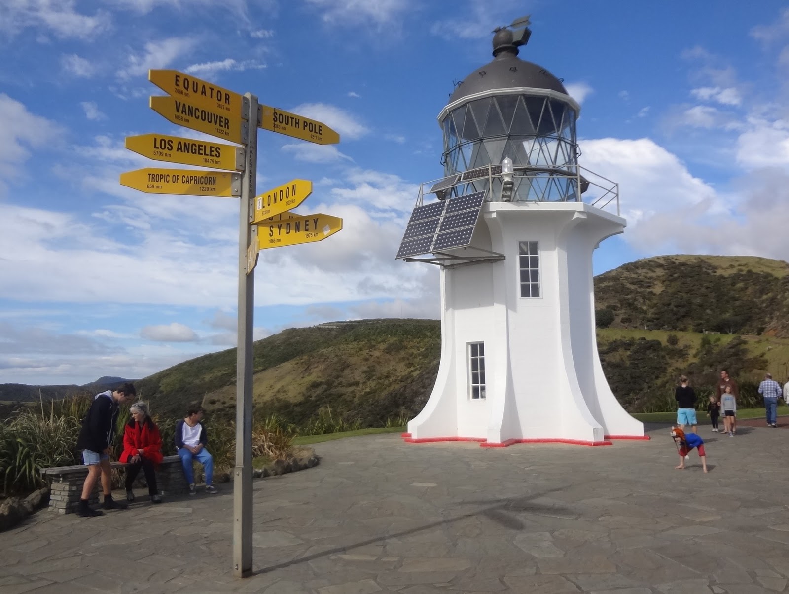
It's been a long road – 1452 km, if you
believe the sign here in Cape Reinga, although the sign from Bluff reckons it's
about 50 km shorter:


Either way, it's been a long road, but it's
been a good road. One of the best I've had the opportunity to traverse
in a life that's been truly blessed, but there's nowhere else left to go now.
Except back the way I came.
Before I left the tip of Cape Reinga, I
cast my eyes out to sea, where the Tasman and the Pacific meet in a furious
frothing of ocean waves, just in line with the Three Kings Islands off in the
distance. Then, it's back to the parking lot, along the sublime, rocky coast
that faces nothing but the wide world ahead.


I said there was nowhere left to go back –
which is true, but it doesn't necessarily have to be by the exact same
road. We turned off the main highway at Te Paki, the road suddenly transforming
into a quicksand stream that you wouldn't drive over in your rental car, but
that's no worries for a 4WD bus and an unemployed Maori driver.


The stream opened up on Te Paki Sandune,
the biggest mound of sand I've ever laid my eyes on, rising high up above the
ground. Boogie boards and toboggans filled the back of the bus, and they were
put to good use here, shooting down over the slope and scrambling back up
again. We all ended up picking sand out of our hair and mouths, but what had
been polite conversation in the small bus that morning was a lot more laughing and
carrying on when we left the dune.


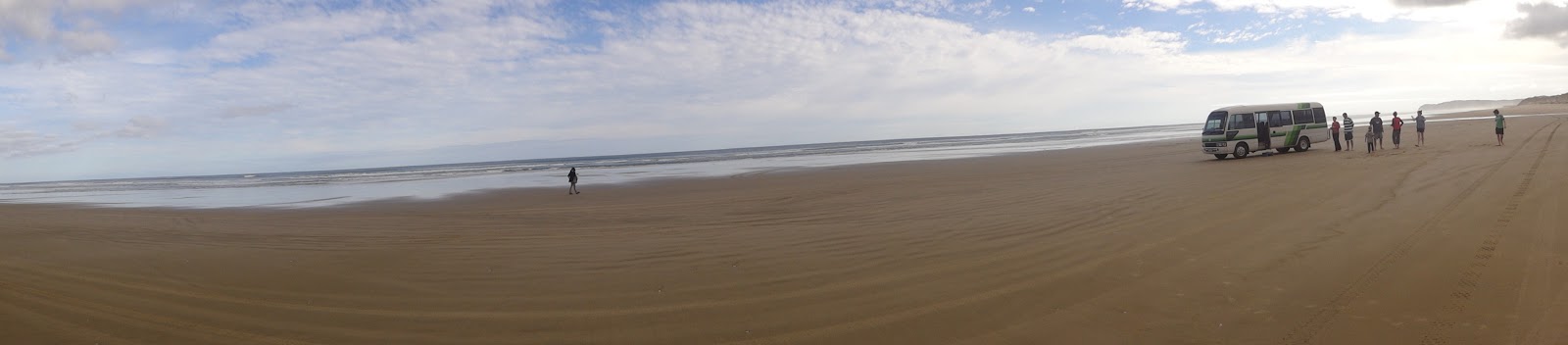
Not that we were headed back to the regular
highway just yet. Ninety Mile Beach (real length: 55 miles) runs down the west coast of the tiny
Aupouri Peninsula, a long strip of hard-packed sand that was once the
legitimate roadway in the area. It still sees plenty of tire tracks these days
– the regular rules apply here, although they're not exactly enforced. Plenty
of people come out here in their own vehicles, digging for shellfish or just
seeing what kind of skid marks they can make on the long, lonely strip of
beach. It's not without its risks though, no matter how solid it might seem –
bus drivers know the route, but others are discouraged from attempting the
drive down the coast, vehicles getting stuck every year. I'm nearly convinced that
same kind of moronic tragedy happened in that little sandy patch around the
bend from Pasadena Beach around 2007, but can't for the life of me remember who
was driving (though I have a pretty good idea).


The tours in this area (and there are many
tour companies, around two dozen) make their schedules based on the tides.
Morning high tide (like this day) mean that you drive up Highway 1 and back via
Ninety Mile Beach – and not just a little skirting on the sand, to say you did
it. We drove back the whole way, sea to the right, dunes to the left,
and nothing but sand ahead of us. With some Maori singing on the way, no less.


I continued back down the coast on my own,
through Northland and on to Whangarei. Now, I've got one last load of washing
to do and a final reassembling of my backpack in preparation for my return to
Auckland on Friday morning. I started this trip by going to a TV taping (Jeaopardy!
in Los Angeles – did you make sure you watched it when it aired in
February?), and I'll end it by sitting in the audience for New Zealand's Got Talent. Between that and buying some Kiwiana crap for souvenirs, the only other thing I need to do is make sure I don't miss my flight in a week's time. You
can put the kettle on soon.
Cheers,
rb
No comments:
Post a Comment